 |
|
Great Rides Ones that Missed out on the 200 Top Rides
I dont want to compete with or worse, duplicate, the 200 Top Rides from the Australia Motorcycle Atlas. You can readily reference there the 100 top rides of the country and now, from the fourth edition, the second 100 top rides! Recently, I was introduced to two rides that have not made either list but are worthy of being sought out and enjoyed. They would certainly rate as comparable to most in, at least, the second 100 top rides. That prompted me to reference them in a page on this site. Hopefully there will be others. Granya Gap Road (Victoria) This road joins the Murray River Road running along the southern banks of the Murray River east of Albury/Wodonga and the Murray Valley Highway (east) which runs south of the southern arm of Lake Hume fed by the Mitta Mitta River. The Murray River Road gets into the 100 top rides at #52 and the Murray Valley Hwy (east) gets in as #53. The Granya Gap road is a short 18km link between the two. Its northern end is between Talgarno and Walwa; and its southern end is east of Tallangatta. However, in whichever direction you ride it, its essentially a winding climb up to the gap and back down again. The turns are pretty constant and fairly rhythmical probably why it seems to be a magnet for the weekend sports bikes. It seems to have claimed a few along the way. A few of us have found it a very worthwhile and enjoyable segment to include in rides that traverse the area, for example, if heading to Phillip Island or simply on a two or three day jaunt from wherever. I have added it as an alternative segment to the route suggested between Melbourne and Canberra on the Practical Routes page. If youre in a sight-seeing mood, theres a road from Granya Gap that runs to Mount Granya at 870m. Its about a 6km run of unsealed road. I havent done it but was assured theres a spectacular view. (Granya Gap, I guess, is what the Bhutanese would call a pass; so we could name it Granya La. You wont find it adorned with prayer flags or chortens, as is every La (pass) in Bhutan, but we did find the outside of the General Store in Walwa decked out in Buddhist prayer flags. It was a real touch of Bhutan. If these observations seems obscure, check out this page. ) Heres a map of the Granya Gap Road:
Tarago/Nowra (NSW) This is a very pleasant and interesting ride of 124km of good bitumen road apart from a 3km stretch of dirt, which on the day we did it had firm wheel tracks with a thin spread of loose gravel between them. The dirt segment was very straight-forward riding. The terrain alternates between open farm land, thick and thinly wooded areas, rock-cliff faces, and escarpments. Theres no shortage of turns that range from fast sweepers to tight twists in the eastern sectors that would warrant advisory signs of 25kph if there were any.
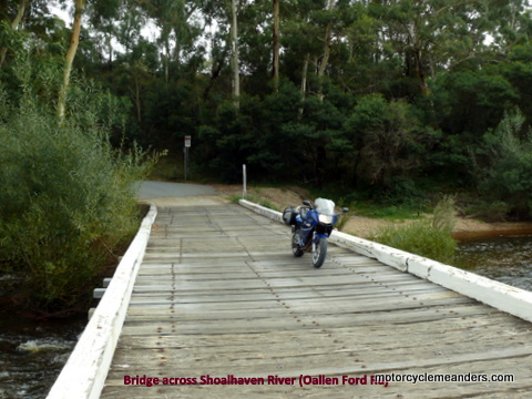
As a guide, the first road from Tarago is called Cullalla Rd. The first Nowra sign is at what looks like the third road off to the right from Cullalla Rd. In fact the seemingly right hand turn is a continuation of Cullalla Rd where it intersects with Tarago Rd. Soon after, Cullalla Rd meets Sandy Point Rd. Theres a turn to the left here onto Sandy Point Rd. Sandy Point Rd meets Oallen Ford Rd; and you turn right onto Oallen Ford Rd for quite a stint through rugged national park country and across the Shoalhaven River partly on an old wooden bridge and partly along the Nerriga has a neat-looking pub. We had a pleasant morning tea there, but we pre-arranged it, so the pickings might be slim otherwise (as other riders have found). Further along theres the Tianjara Falls. Theyre certainly worth a look. Theres a bitumen road into them. Its only 100-200m into the car park and about a 50m walk to the viewing platform. From here, theres just more great escarpment riding to the Princes Hwy. Heres a map of the Tarago/Nowra ride:
Return to the Top of Page Go to On the Road |
 The western end of this ride is Tarago, a small hamlet on the under-utilised Canberra/Goulburn rail line and home to the Loaded Dog Hotel. From Tarago, heading east from the Loaded Dog intersection, you basically follow signs that point you to Nowra, but you need to look out for them as theres a few turns you might not instinctively take.
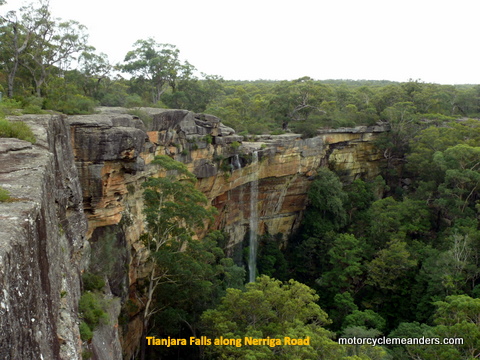 Oallen Ford, presumable after which the road has been named. The ford is, in fact, not across the river as such but across what looks like a flood plain. Eventually Oallen Ford Rd meets up with the Nowra/Braidwood Road or Main Road #92 or Nerriga Rd. It seems to have a few identities.